For satellite operators, the launch of their spacecraft is the most exciting and frightening thing at the same time. The highest risk of losing the mission is in these early operational stages of the mission. Assuming the launch itself performs nominally and reaches the envisaged target orbit, the spacecraft must be released from the upper stage or be ejected from the dispenser. For launches with many spacecrafts onboard batch releases are performed which need to ensure separation between each of the buses on their new orbit. Following the release, the spacecraft needs to be commissioned and made ready for the first operational steps. For this, the operator needs to acquire a signal from the spacecraft and establish contact to communicate, get the first telemetry and send commands. The initial position estimate is usually shared by the launch provider. It helps to steer the antennae and telescopes for the first passes over the ground stations. To be able to track and communicate beyond the first day, own orbital solutions need to be generated. The generation of the TLE from public sources usually takes a while, from days to weeks, depending on the orbit (LEO or GEO). Without updated orbital data, the operator risks losing contact and is also not able to maneuver safely.
The challenges that need to be tackled can be summarized as:
- Monitoring spacecraft separation from the upper stage,
- Monitoring spacecraft separation from the satellite dispenser,
- Identifying the own spacecraft from a batch of released objects,
- Establishing first contact,
- Get a first (good) orbit solution
- Preparing first safe maneuvers,
- Maneuvering into the foreseen target orbit.
Especially first-time operators need to prepare well for this critical phase, as this requires working against the clock.

To mitigate the risk and keep the young mission successful early on, operators need to be prepared by
- creating an operations plan from contacting the spacecraft after release to maneuvering it into the target orbit and slot,
- making sure data will be available, from the RF antenna, onboard GNSS sensors and third-party SSA or STM services,
- setting up processing chains for orbit determination, orbit propagation, correlation, conjunction screening, and
- dry running the plan by checking interfaces and data formats, especially when third-party providers are involved
Preparation is key
Below is an exemplary timeline for a LEO Earth observation mission, released from a SpaceX Transporter launch. It is separated into phases starting 14 days before the launch and continuous until the desired orbit slot is reached.
The setup should occur well in advance, in this case two weeks before the launch. From our experience, data that is exchanged with partners usually embraces a certain standard, like the well-known Orbital Ephemeris Messages (OEM), defined in the CCSDS ODM document. Sometimes SSA providers or operators follow their own interpretations, including but not limited to the use of exotic reference frames and timescale definitions or the use of different units (meters instead of kilometers) than expected. To find these small deviations a rehearsal is scheduled, with enough time to handle and fix these issues.
A few days before the launch the satellite operators receive updates from their launch provider with launch and deployment preliminary data as Two-Line Elements (TLEs) or Orbit Mean-Elements Messages (OMMs), corresponding with the current launch window. With this information, the first ground-station passes can be booked and the SSA partners can be notified for the scheduling of tracking sensors.
After a successful launch, the launch provider additionally shares post launch TLEs/OMMs that help to better track the object, which should be closer to the reality. Following the release milestone, commissioning begins, eventually leading to the first thruster tests and the first orbital maneuver. With this, the orbit update and screening cycle starts. A maneuver needs to be performed in a coordinated manner, especially after the deployment, when other spacecraft are in the vicinity. The SSA/STM providers are able to process orbital data from tracking and on-board GNSS systems to determine the best trajectory and also help by screening for close approaches resulting from the planned maneuver. The data exchange between the operator and the SSA/STM provider in this phase involves information on the satellite’s capabilities during or right after the commissioning, first GNSS data and maneuver information. Additionally, observations may be available from tracking partners. The first independent products in the form of TLEs, OMMs, OEMs and conjunction data messages (CDMs) can be provided hereinafter. Public providers like EU SST and Space-Track are able to provide their first solutions between days to weeks after the launch. Sharing these orbit solutions helps them to correlate and catalogue the newly launched satellite(s).
The process remains similar for subsequent maneuvers into the corresponding orbit slots. SSA/STM providers are usually not aware of maneuvers and as such have big uncertainties in their orbit solutions. Sharing the maneuver plans helps the orbit determination process reach a more accurate solutions and fewer close approach false alarms.
.png)
3 … 2 … 1 … liftoff
In this example a GEO operator is being supported in the LEOP activities. A similar timeline as depicted above is followed. The operator shared their satellite information, LEOP and orbit transfer plans after deployment in advance. OKAPI:Orbits then checked the possibility of observations with their sensor data providers, that operate worldwide telescope networks. The first exchange of data in the rehearsal revealed that OEMs in a certain format are prepared by the operator (CCSDS OEM as KVN instead of XML or JSON format). For the communication, dedicated eMail accounts were set up with the operation teams on OKAPI:Orbits and the satellite operator's side. Since it is a delicate moment, easy communications and quick response times are key.
The launch was pushed back multiple times due to weather conditions, which led to updates of the initial TLE and a re-evaluation of the visibility conditions within the contracted telescope networks. In the end, the launch worked out perfectly placing the upper stage where it was predicted to be, allowing first observations from the telescopes.
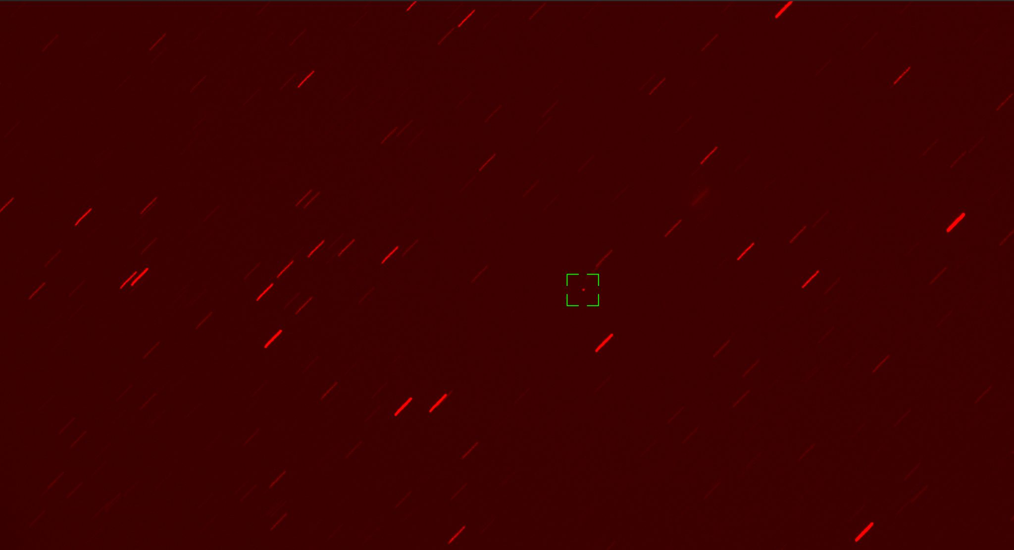
After deployment, just some hours later, three new space objects were detected and a correlation between subsequent observation epochs was needed to perform the first orbit determination. The graph below shows multiple tracks at different epochs shortly after the deployment. We correlated the correct combination (1B2C) for our target satellite. The other combinations matched the other satellites also deployed in this launch, since they were still close enough to be in the telescope's field of view. The identification of our target satellite was done by means of the orbital elements.

The first solutions were used to re-observe the satellite as it moved away from the upper stage and the second satellite that had also been deployed. OEMs and TLEs were generated as well. The ephemeris were used for the first conjunction screening, serving as decision input in the operations team to perform the first maneuver. The conjunction screening relies on the data sources that are available at the time, which includes the SP data from 18th & 19th SDS, which are high accuracy ephemeris, customer ephemeris and processed observations from our own partner sensor network that are used to create our own customer-centric neighborhood catalogue. The neighborhood catalogue creates awareness specifically for satellites in their respective slots with a 30-day forecast of objects entering the bounding box. Follow-up observations and analysis are performed only on the relevant subset of objects for a neighborhood catalogue.
The graph below shows the angular residuals from the early orbit determination based on the correctly correlated tracks. The smooth dispersion around 0 arcseconds hints at good observations and a good initial orbit determination solution.

The thruster ignition was successful, paving the way for the next step of raising the orbit and moving into the envisaged GEO slot. The LEOP is finished.
Conclusion
In this campaign we provided LEOP support for a GEO mission, over 30 days from release until the target slot was reached. Our sensor tasking, correlation and orbit determination provided near real time orbit solutions that guided the operations team in quickly performing the first maneuvers. Our LEOP service showed much quicker results than public providers are able to achieve, which is hours instead of days or even weeks.

%20(1)%20(1)%20(1).png)